
Professor, University of Texas and ICESat-2 Science Definition Team Leader, NASA
 In this issue’s Q&A, Texas+Water Editor-in-Chief, Dr. Todd Votteler, interviews Dr. Lori Magruder, research scientist at the University of Texas’ Applied Research Laboratories and the Ice, Cloud and Land Elevation Satellite-2 (ICESat-2) Science Definition Team Leader for NASA. Her technical background is in aerospace engineering, with a focus on lidar remote sensing.
ICESat-2 is part of NASA’s Earth Observing System. It is a satellite designed to measure ice sheet elevation and sea ice thickness, as well as land topography and vegetation characteristics. ICESat-2, a follow-on to the ICESat mission, was launched on September 15, 2018 from Vandenberg Air Force Base in California, into a near-circular, near-polar orbit with an altitude of approximately 496 km (308 mi).
ICESat-2 is a follow-on mission to ICESat-1. What did we learn from ICESat-1 and what do you anticipate we will learn from ICESat-2?
 The original ICESat contributed to so many scientific disciplines with its global elevation measurements. The ice sheet elevations helped us understand how the ice was changing over time. These time series give us a glimpse into how trends in ice melt change the sea level and impact our climate. Similarly, ICESat gave us a broad look at polar oceans and the size and extent of those frozen portions (sea ice) that play a critical role in maintaining ocean temperatures. We also learned about tree structure and had the first insight into global canopy heights to inform us on the Earth’s carbon storage in vegetation. In addition to ICESat’s success with the primary mission objectives it allowed for advancement in unexpected ways. For example, Prof. Helen Fricker (Scripps Institute of Oceanography) discovered a hidden lake under a glacier in Antarctica. ICESat repeatedly measured its filling up and emptying based on the water surface level. The volumes of water and their rates of transfer were determined to be much larger than those previously thought possible. The lake would have remained hidden had Prof. Fricker not seen it in the ICESat data.
ICESat-2 will pursue similar mission objectives to its predecessor but with new technology that will allow for more coverage of the Earth and the ability to smaller details on the surface. The data will provide for new discoveries but also extend our knowledge of elevation change over time. One exciting feature of ICESat-2, that wasn’t part of the original ICESat mission is its capability to see under water. The green laser wavelength is unique in that it will measure the elevation of the water surface but also penetrate that surface so we can see what the sea floor looks like in coastal or shallow water regions. This capability opens up a new area for science innovation within the mission!
When will ICESat-2 begin to provide results, how long will the mission last and are the technological differences between ICESat-1 and 2 satellites?
ICESat-2 mission requirement was for a 3-year operational lifetime. However, there is enough fuel on-board to keep it going for 5+ years. The technologies used for ICESat and ICESat-2 are quite different. The instrument onboard ICESat was a single beam, full-waveform lidar called the Geoscience laser Altimeter system (GLAS). Lidar is the acronym for LIght, Detection And Ranging, also known as laser ranging or laser altimetry. GLAS operated at 40 Hz which provided a single 70 meter (230 feet) diameter laser footprint on the ground every 170 meters (558 feet). The measurement plan for ICESat was to collect data over a uniformly distributed set of satellite ground-tracks every three months. The repeat measurements were to help determine surface change across each season.
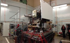
However, this plan was altered once on-orbit due to a design flaw in the laser and the functionality of the instrument was preserved by reducing the data collections from continuous to selected seasonal campaigns. The revised operational strategy reduced the amount of data collected, so the scientists didn’t get as much information about surface changes or surface detail. ICESat-2 carries a photon-counting lidar called ATLAS (Advanced Topographic Laser Altimetry System). Photon counting lidar is relatively new to the remote sensing community and implies that the instrument receiver is sensitive to individual photon detections. This sensitivity means that the system does not require a high power laser which saves on-board weight and power levels while allowing for higher data collection rates. ATLAS produces 6 individual beams, each footprint is 14 meters in diameter and given the 10 kHz repetition rate it can illuminate the surface of the Earth every 70 cm (27.5 inches) – creating a continuous along track elevation profile. The orientation of the beams allows scientists to disentangle surface slope from true elevation change, which isn’t possible with a single beam system.
How do NASA missions like the ICESat missions advance our knowledge of the world’s water and climate, and how do they benefit water management? Does NASA obtain input from water resource managers when developing missions such as ICESat?
NASA selects a science definition team to support the mission early in the process. This team is comprised of 12 individuals that bring different expertise to the table. Some of these folks are experts in hydrology. The diversity of expertise is somewhat unique to ICESat-2 because of the potential use of the data by so many different scientific communities. There is also diversity in ICESat-2’s data products. There are data products dedicated to land ice, sea ice, vegetation and the atmosphere. There is also a data product dedicated to inland water and the oceans. ICESat-2 will advance our knowledge of the Earth’s reservoirs and inform global water storage. There is potential to use these inland water data to provide floodplain inundation dynamics, understand flood event seasonal characteristics and assess river flow and discharge. The lake bottom mapping under the water surface and volume estimates using ICESat-2 data will be essential for water resources management
The Geospatial Laser Applications and Measurements (GLAM) group is part of UT Austin. Does this mean undergraduate and graduate students are participating in the research?
 Yes, the GLAM research group is at the Applied Research Laboratories, which is part of UT Austin. We are not affiliated with a specific college/department at UT but report directly to the University Vice President of Research. As such, we have all levels of researchers working at here (undergraduate, graduate, post-docs and junior and senior research staff) from many different backgrounds (math, physics, engineering, etc.). The lab even has a program that selects high school seniors interested in a technical field for summer research position.
The opportunity to work with NASA would be a dream job for most scientists. Has Earth science been a lifelong focus for you?
My area of study was Aerospace Engineering with an academic focus in spacecraft dynamics and remote sensing. While in graduate school, my Ph.D. work was with ICESat. I was leading efforts in how to ensure that the data was within the performance requirements of the mission. The validation work allowed me to build specialized detectors that would capture the laser from space and accurately determine the measurement time and quality, which was the perfect combination (for an engineer) of instrumentation, theory and application. I loved it and working with the NASA team was an amazing experience. Now, since ICESat-2 has become a reality I get to live the dream all over again, albeit in a slightly different capacity and hopefully providing more knowledge and experience than during my days in school. When I saw ICESat launch we all said it was a once in a lifetime experience- but fortunately that once in a lifetime experience has happened twice and I look forward to many more before I’m done.