
SUMMARY:
- After a record warm September, October came in cooler than normal.
- Drought coverage decreased from 52 percent to 32 percent.
- The El Niño Southern Oscillation is expected to remain in neutral conditions through the spring.
I wrote this article on November 17, 2019.
I’m a major fanboy of Nate Silver, he of fivethirtyeight.com and his hyperly geeky, yet accessible, discussions of polling and other statistical data. I’ve been reading his book, The Signal and the Noise: Why So Many Predictions Fail—And Some Don’t, where he discusses predicting earthquakes, baseball careers, poker hands, and, yes, the weather.
One fascinating—but statistically disheartening—discussion is how national and local private-sector weather workers “enhance” forecasts from the National Weather Service. For example, you’ll rarely, if ever, see a forecast of a 50-percent chance of rain from private predicters. Private forecasters will either round up to 60 percent or down to 40 percent. That’s because a 50-percent chance of rain suggests the forecaster doesn’t know if it’s going to rain or not, which the viewing public apparently doesn’t appreciate.
Another thing private forecasters do is round rain chances of less than 20 percent up to 20 percent because viewers get upset when there’s a small-sounding 5-percent chance of rain and it rains on their parade (despite there being a 1 in 20 chance of rain). Just this past week, I heard a local forecaster say “There’s a slight chance of rain on Wednesday.” while the graphic on the screen stated “20% chance.”
Silver’s respect for the National Weather Service clearly shines through the dark clouds of climatic uncertainty. The Service is always evaluating the accuracy of its predictions and keeping the science of forecasting away from the policy of issuing weather warnings.
Speaking of weather, cooler temperatures finally swooped into Texas over the past month. After the warmest September on record for the state, October came in half a degree cooler than normal. North and Southeast Texas received five or more inches of rain with much of the central part of the state receiving two to three inches and the western part of the state receiving less than two inches over the past month (Figure 1a).
Much of the Gulf Coast, parts of North Texas, and an east-west blob centered on Lubbock received better-than-normal amounts of precipitation over the past month with much of the rest of the state receiving less than normal amounts (Figure 1b). Parts of the Panhandle and Far West Texas received less than 25 percent of normal precipitation (Figure 1b). Looking over the past 90 days, most of the center of the state is still experiencing a rainfall deficit (Figure 1c).
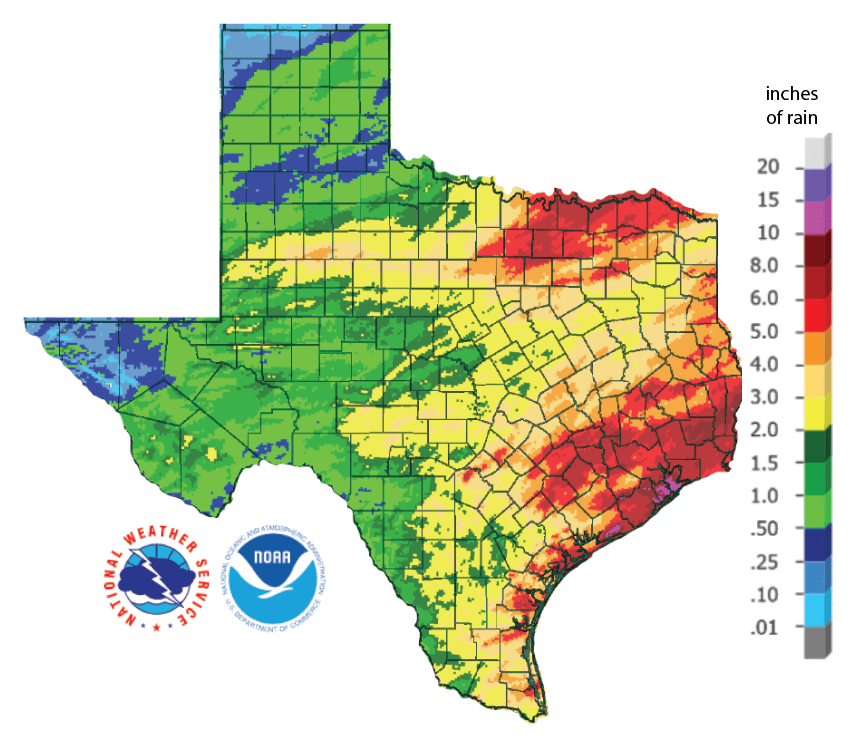
Figure 1a: Inches of precipitation that fell in Texas in the 30 days before November 17, 2019 (source). Note that cooler colors indicate lower values and warmer indicate higher values.
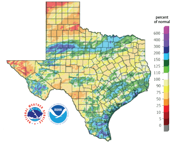
Figure 1b: Rainfall as a percent of normal for the past 30 days (as of November 17, 2019; source).
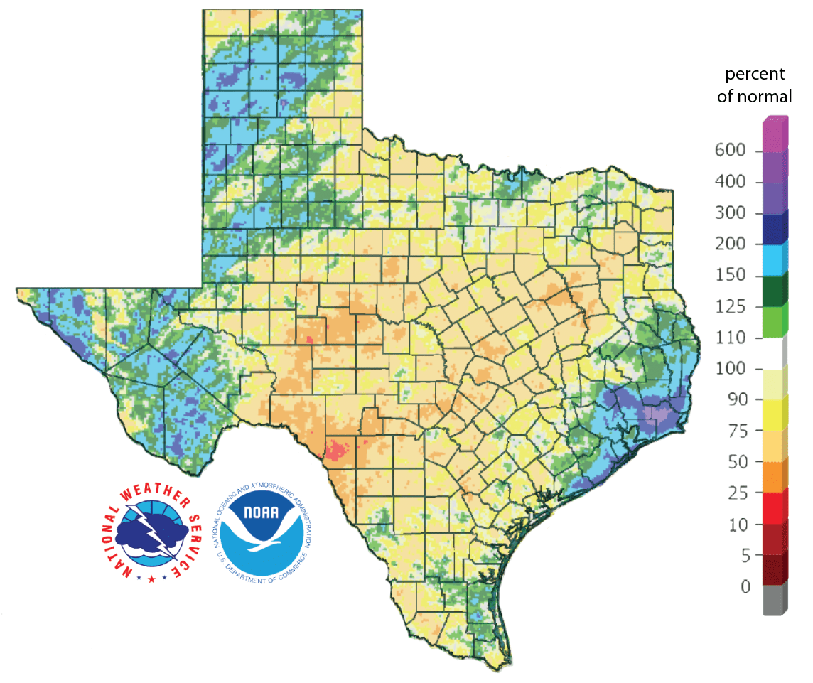
Figure 1c: Rainfall as a percent of normal for the past 90 days (as of November 17, 2019; source).
Drought coverage decreased about 20 percentage points over the past four weeks from 52 percent a month ago to 32 percent today with 53 percent of the state either abnormally dry or in drought (Figure 2a). We saw drought improvement across much of the region (Figure 2b), but extreme drought remains in the Uvalde-Zavala county area and in the Jim Hogg-Zapata county area (Figure 2a). Severe drought remains in the areas just mentioned but also for the San Angelo area stretching up to the Brazos River (Figure 2a).
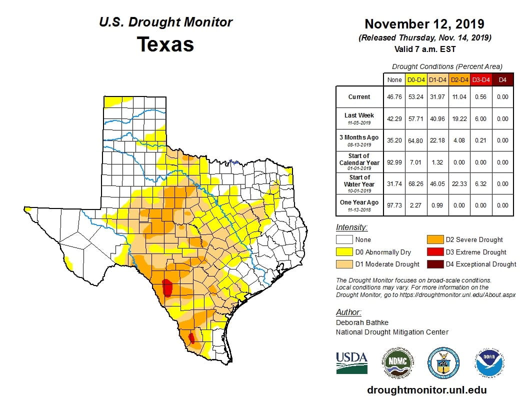
Figure 2a: Drought conditions in Texas according to the U.S. Drought Monitor (as of November 12, 2019; source).
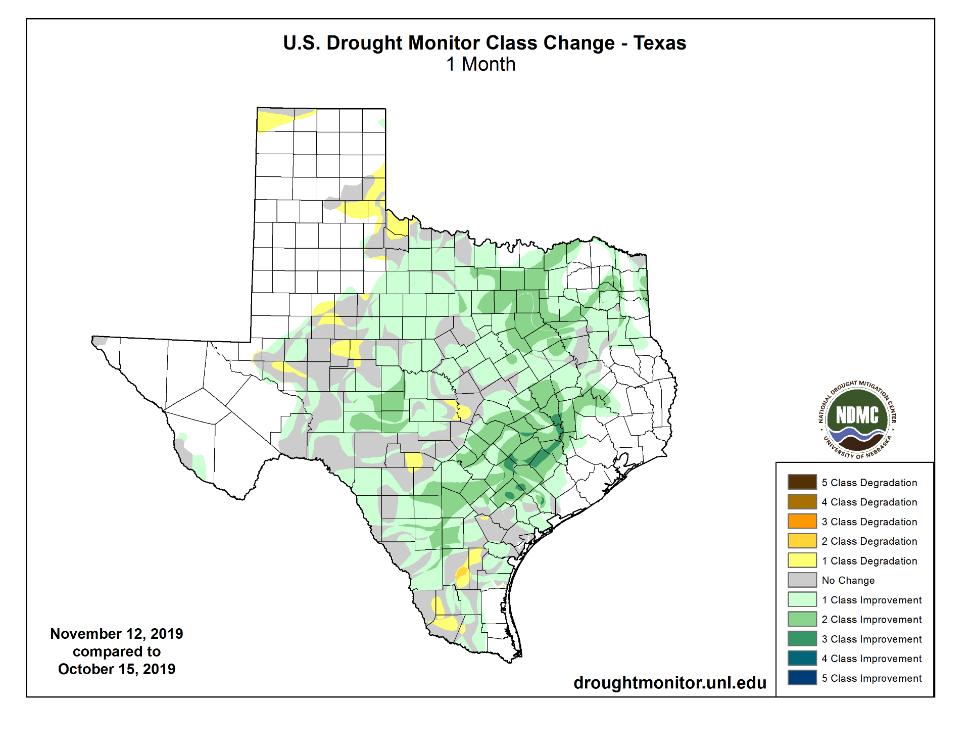
Figure 2b: Changes in the U.S. Drought Monitor for Texas between October 15, 2019, and November 12, 2019 (source).
The North American Drought Monitor for October shows a degradation to moderate-to-severe drought in the headwaters of the Rio Grande in Colorado, a primary source of water to Elephant Butte Reservoir (Figure 3a). Abnormally Dry to Moderate conditions remain in the headwaters of the Rio Conchos in northern Mexico south of Big Bend, a major source of water to Lake Amistad (Figure 3a). Percent of normal precipitation in the Rio Grande watershed in Colorado over the last 90 days is less than 25 percent of normal for much of the watershed (Figure 3b).
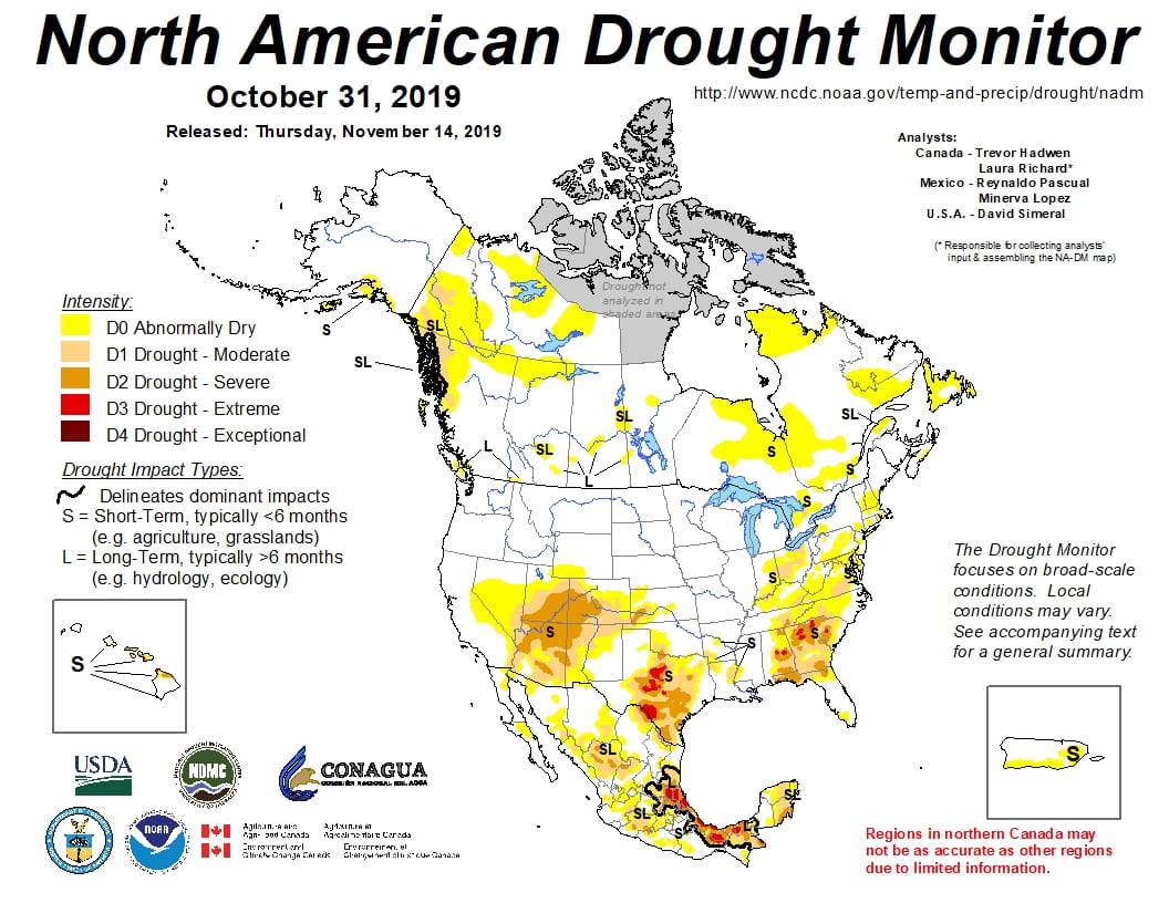
Figure 3a: The North American Drought Monitor for October 31, 2019 (source).
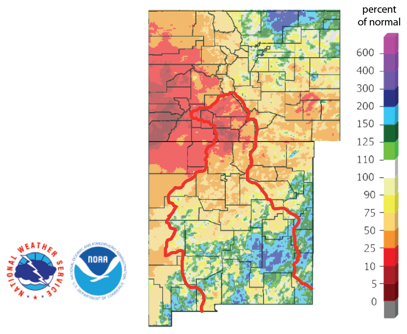
Figure 3b: Percent of normal precipitation for the past 90 days for Colorado and New Mexico as of November 17, 2019 (source). The red line is the Rio Grande Basin. I use this map to see check precipitation trends in the headwaters of the Rio Grande in southern Colorado, the main source of water to Elephant Butte Reservoir downstream.
Statewide reservoir storage bottomed out last month at 80.9 percent and has now risen to 81.1 percent, slightly above the median storage since 1990 for this time of year (Figure 4a). Storage in individual reservoirs remained relatively stable over the past month (Figure 4b). Lake Meredith continues to look good, at least compared to the recent drought, with conservation storage at 41 percent with ~207,000 acre-feet of water in storage (Figure 4c).
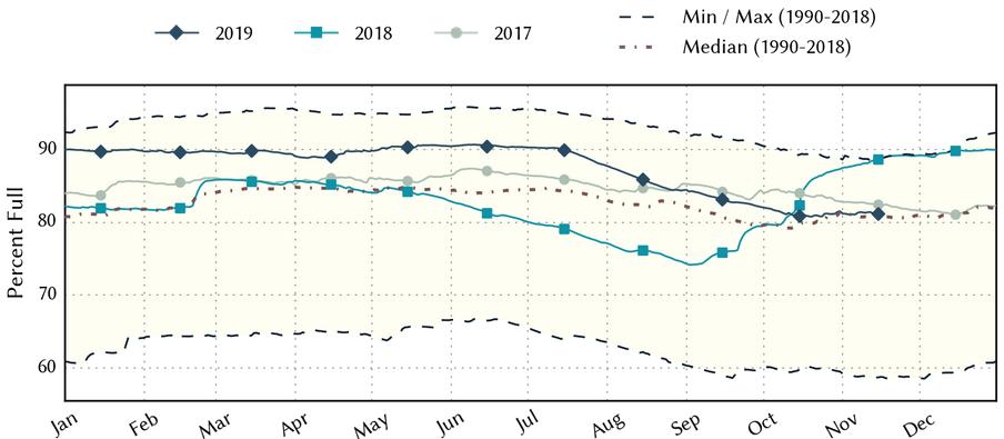
Figure 4a: Statewide reservoir storage since 2017 compared to statistics (median, min, and max) for statewide storage since 1990 (source).
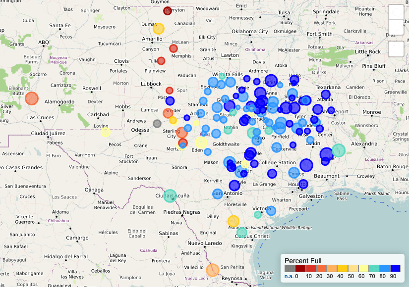
Figure 4b: Reservoir storage as November 17, 2019, in the major reservoirs of the state (source).
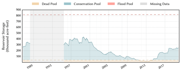
Figure 4c: Reservoir storage in Lake Meredith since 1986 (source).
For the El Niño Southern Oscillation, we remain in neutral (La Nada) conditions (Figure 5). The Climate Prediction Center has a ~70 percent chance of neutral conditions continuing through the winter and a 60- to 65-percent chance of continuing through the spring.
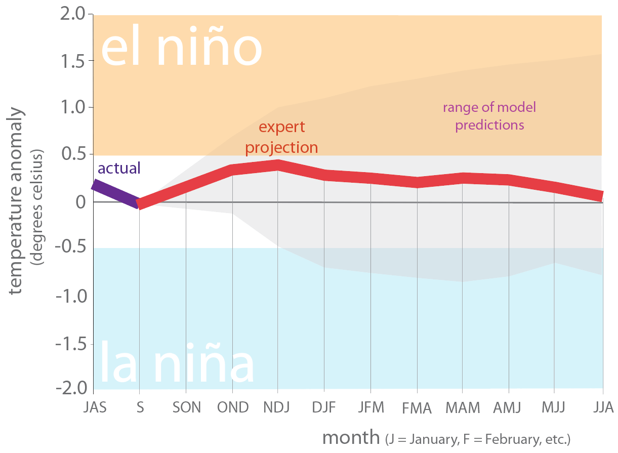
Figure 5. Forecasts of sea surface temperature anomalies for the Niño 3.4 Region as of October 18, 2019 (modified from source).
The U.S. Seasonal Drought Outlook through February 29, 2020 projects that current drought conditions will persist with additional drought development across the center of the state (Figure 6).
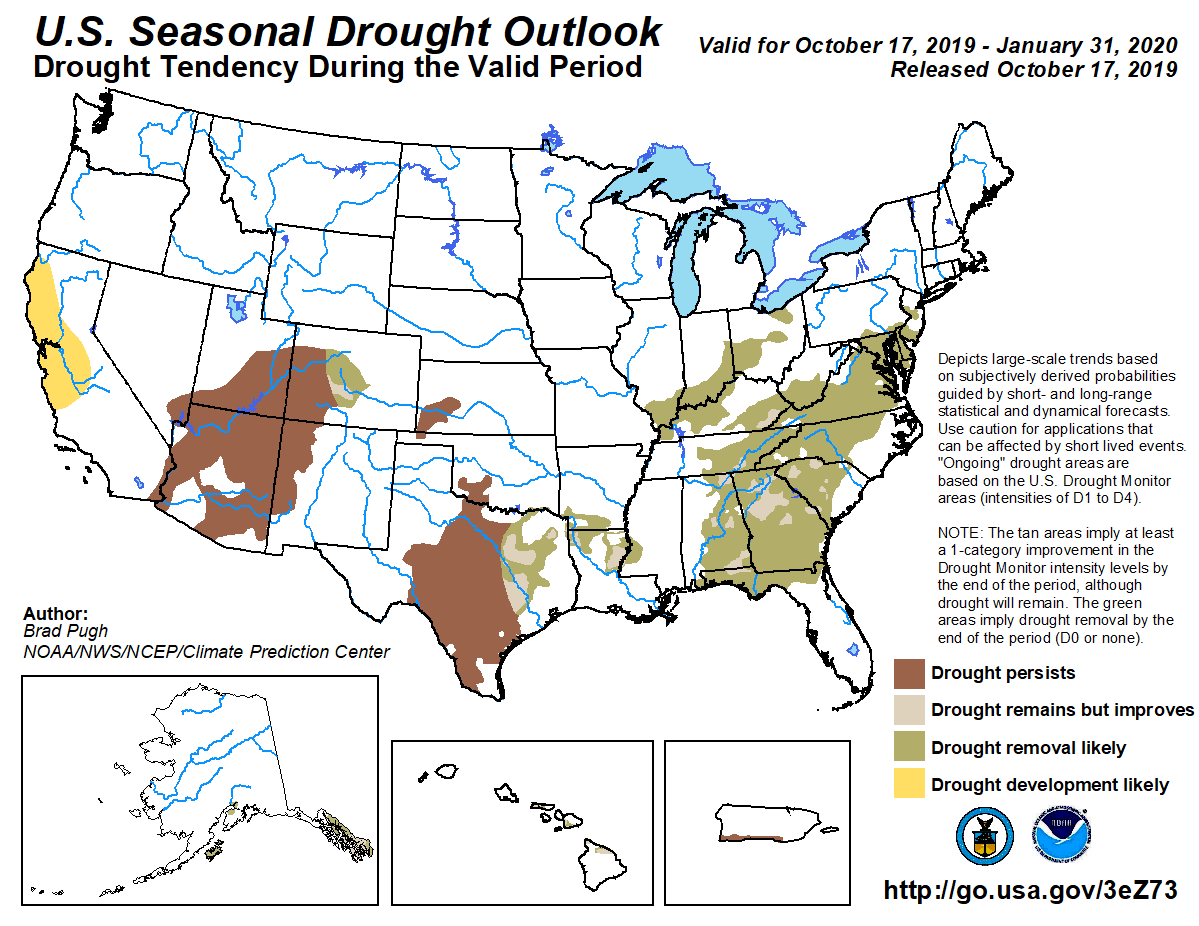
Figure 6: The U.S. Seasonal Drought Outlook for November 21, 2019, through February 29, 2020 (source).
Author

Robert Mace
Interim Executive Director & Chief Water Policy Officer at The Meadows Center for Water and the Environment
Robert Mace is the Interim Executive Director and the Chief Water Policy Officer at The Meadows Center. He is also Professor of Practice in the Department of Geography at Texas State University. Robert has over 30 years of experience in hydrology, hydrogeology, stakeholder processes, and water policy, mostly in Texas.