 With 38 public universities and 35 private colleges and universities in the state and many more across the country (and the world) interested in Texas, there’s a great deal of academic scholarship focused on water in the Lone Star State. In this column, I provide brief summaries to several recent academic publications on water in Texas.
I strive for five papers but only present three this month because two of the five papers I read should have been smothered to death in peer review. So, in a sense, the papers below are ones I believe deserve some attention.
However, I should note that I only know what I know, so I could be hoodwinked by well-written papers outside of my expertise. At the very least, the papers below made it through the Mace Krapp-Filter© and may be deserving of your time and consideration. The path to truth through science can be messy because it is, at its core, a human endeavor. But I have faith that science—in the collective hands of the capable and competent—will get us there.
Let’s start thinking about water!
Assessment of subsidence risk associated with brackish groundwater development in the coastal lowland aquifer
As the greater Houston area grows and looks for more water, the brackish groundwater resources beneath the city become more enticing since they are local and untapped. However, besides being famous for traffic, humidity and the Beer Can House, Houston is also famous for groundwater-pumping induced land subsidence. Using field measurements and models, Deeds and others (2020) took a look at the potential for land subsidence if brackish groundwater resources are pumped. The bottom line is that the potential and risk of land subsidence for brackish groundwater resources is similar to that for fresh groundwater where the risk is higher for shallower sources than it is for deeper sources where the formations are pre-squished from thick overburden.
Citation:
Deeds, N., Turco, M., Kelley, V., Petersen, C., and Board, S., 2020, Assessment of subsidence risk associated with brackish groundwater development in the coastal lowland aquifer, Houston, Texas, USA: Proceedings of the International Association of Hydrological Sciences, v 382, p 437-441.
Prioritizing riparian corridors for ecosystem restoration in urbanizing watersheds
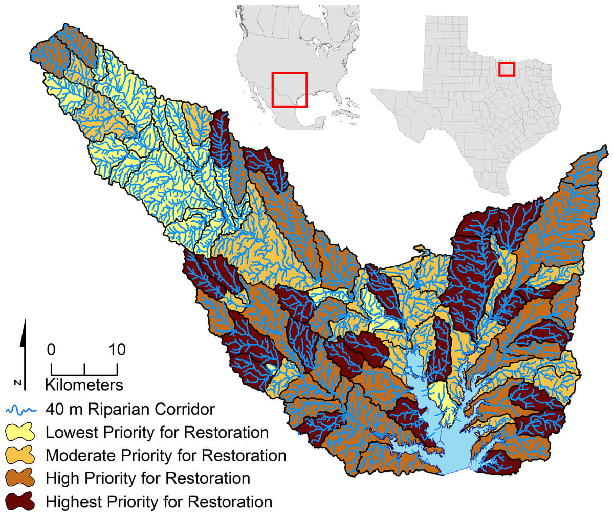
After horrific flooding in the Hill Country and the Houston area, Texans are thinking more and more about flood protection and how natural solutions, such as riparian management, can help. Atkinson and Lake (2020) developed a GIS tool to prioritize riparian corridors in urban watersheds for restoration to complement an earlier tool they developed for prioritizing pristine riparian zones for preservation. As the authors note, riparian areas reduce erosion, filter sediments and pollutants, moderate water temperatures, provide habitat and store water to moderate flooding. They tested their tool—which prioritizes based on native vegetation cover, erodibility and slope—on 90 sub-watersheds in North-Central Texas. Given that two-thirds of the US’s riparian ecosystems have been converted to non-native land-uses, restoring riparian corridors can provide multiple benefits.
Citation:
Atkinson, S.F., and Lake, M.C., 2020, Prioritizing riparian corridors for ecosystem restoration in urbanizing watersheds: Peer J, DOI 10.7717/peerj.8174, 24 p.
A comparison of streamflow and baseflow responses to land-use change and the variation in climate parameters using SWAT
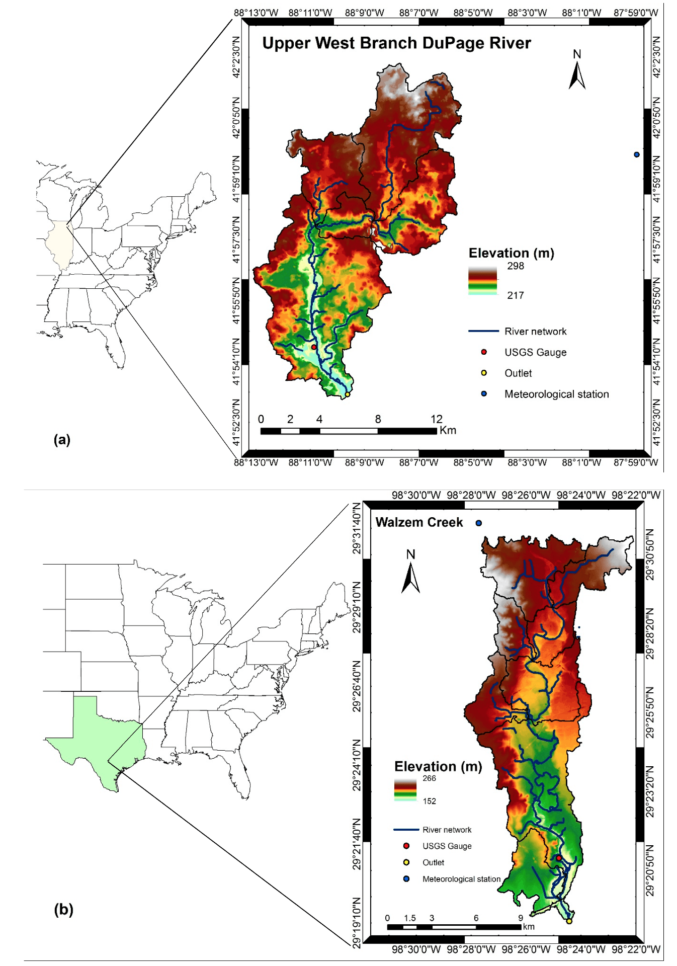
Urbanization and climate affect watersheds, and with both changing over time, it can be difficult to assess who is doing what. Aboelnour and others (2020) investigated urbanization and climate effects on two watersheds, one in Indiana and one in Texas, specifically Walzem Creek in the San Antonio area. Using the Soil and Water Assessment Tool and a method called “change-fix,” they were able to show that changes in streamflow and baseflow in Walzem Creek appear to be caused more by urbanization than climate variability. Nonetheless, increased temperatures and decreased rainfall appeared to cause overall flow in the creek to decrease by 11.9 percent and baseflow to decrease by 42.9 percent while combined urbanization and climate variability decreased overall flow by 25.7 percent and baseflow by 67.9 percent.
Citation:
Aboelnour, M., Gitau, M.W., and Engel, B.A., 2020, A comparison of streamflow and baseflow responses to land-use change and the variation in climate parameters using SWAT: Water, v 12, n 191, doi:10.3390/w12010191, 30 p.
Join Our Mailing List
Subscribe to Texas+Water and stay updated on the spectrum of Texas water issues including science, policy, and law.